


les eparges

jcb48
User
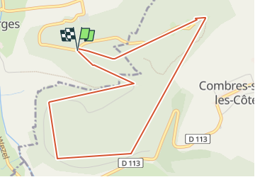

Length
5.1 km

Max alt
359 m

Uphill gradient
130 m
Km-Effort
6.9 km

Min alt
291 m

Downhill gradient
128 m
Boucle
Yes
Creation date :
2025-07-03 07:12:19.888
Updated on :
2025-07-08 16:18:18.356
3h46
Difficulty : Medium

FREE GPS app for hiking
 SityTrail
IGN / Geographical institutes
SityTrail Plus
The world is yours!
About
Trail Walking of 5.1 km to be discovered at Grand Est, Meuse, Les Éparges. This trail is proposed by jcb48.
Description
randonnee
Positioning
Country:
France
Region :
Grand Est
Department/Province :
Meuse
Municipality :
Les Éparges
Location:
Unknown
Start:(Dec)
Start:(UTM)
690288 ; 5437709 (31U) N.
Comments